Jumat, 04 Agustus 2023

Prambanan Temple


Prambanan Temple

Prambanan temple locates in the east part of Yogyakarta, is known as the largest Hindu temple in Indonesia. Nothing word was said of when the temple was built, and who ordered it. But its beliefs were built in the 9th century AD by King Belitung Maha Sambu of the Sanjaya dynasty. The assumption is based on the content Syiwagrha inscription found around the Prambanan and now kept in the National Museum in Jakarta. The stone's inscription was dated 856 AD and written during the reign of Rakai Pikatan.

The restoration takes a long time as if nothing had finished. Prambanan temple was a rediscovery of the great ruins, of Shiva temple reported by CA Lons in 1733. Every effort in excavation and recording of the first was conducted under the supervision of Groneman. The excavation temple completed in 1885 includes cleansing scrub and rock groupings temple ruins.

In the year 1902, the excavations continued efforts by van Erp. Grouping and identification of rock debris are carried out in more detail. Restoration of the Prambanan temple was resumed under the supervision of the Antiquities Department and supervised by P.J. Perquin. Through these efforts, some of the temple's ruins of Shiva were renovated. In 1926, formed a restoration committee temple site under the leadership of De Haan to continue the efforts that have been implemented by Perquin. Under supervision, the development of more refined results Shiva and temples continued renovation.

In 1931, De Haan died and was replaced by V.R. Romondt. The second restoration of the Apit temple was completed in 1932. The restoration was stopped in 1942 when the Japanese took power in Indonesia. After going through the long process and halting the war and the transition of power. The Shiva and Apit temples finished in 1953 of restoration. The Prambanan temple restoration continues implemented gradually.

Senin, 24 April 2017

Borobudur Temple

Borobudur temple is one of the famous tourist attractions in Indonesia located in Magelang, Central Java. Borobudur was built around the year AD 800 or so by the Mahayana Buddhists. In the history of the Borobudur temple, there are several theories explaining the origin of the name Borobudur temple. One is that the name comes from the word Sambharabhudhara Borobudur which means mountain.
In addition, there is some other folk etymology, as the Borobudur derived from the words of the Buddhas is due to the shifting of the sound to Borobudur. Another explanation is that it comes from two words namely Bara and beduhur. Coal comes from the word Vihara, there is also another explanation in which Bara comes from Sanskrit which means temple or monastery complex and meaning beduhur High. Historian J.G. de Casparis found Borobudur is a place of worship. According to the inscription Karangtengah and Kahulunan, Casparis predict who founded Borobudur temple is the king of the Mataram dynasty named Samaratungga, who did the construction in 824 AD.
Building a new temple could be completed by the time her daughter, Queen Pramudawardhani. Borobudur Development is expected to take 50 years. Karangtengah inscriptions also mentioned the bestowal of land sima or tax-free land by Ç.R Kahulunan Pramudawardhani. Location of Borobudur temple was located in the hills above the village of Borobudur, Mungkid, Magelang. Surrounded by Hill Manoreh stretching from east to west. While the east part is Mount Merapi and Merbau and in the west, there are Mount Sindoro and Sumbing.
It takes no less than 5 million, equivalent andesite blocks with 90,000 sq m to build the temple of Borobudur. The overall weight of the temple reached 5.5 million tons. Like most temples, the Borobudur building has 3 parts, namely the legs, body, and top. At the foot called Kamadhatu, tells the story of a life filled with lust and bestiality. Then Ruphadatu, which describes a level of consciousness that is still bound to lust, material, and shape. While the levels are no longer bound Aruphadatu lust, material, and shape are depicted in the form of an empty stupa. It can only be achieved with desire and emptiness.

Kamis, 23 Februari 2017

Sultan Palace of Yogyakarta

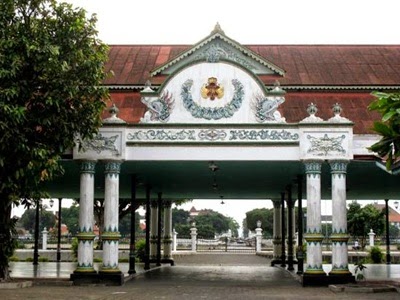
The Sultan Palace Yogyakarta's history began when in 1558 AD, Ki Ageng Pamanahan get a gift from the Sultan area in Mataram for services that has been defeated Aryo Penangsang. Ki Ageng Mangir archery remained always loyal to Sultan Agung to the end, building a palace in Kotagede in 1577. Substitute Ki Ageng Sutawijaya is the son of archery, in contrast to his father. Raden Sutawijaya Pajang refused to submit to the Sultan and want to have their own territory and even dominate the whole island of Java. After winning the battle with the kingdom Pajang in 1588, Mataram became a kingdom and Sutawijaya was the title Sultan Panembahan Senopati. Mataram kingdom has much experienced rapid developments during the reign of Sultan 4th generation, namely Sultan Agung Hanyokrokusumo. After Sultan Agung died and then was succeeded by his son, named Amangkurat 1.
Mataram kingdom suffered internal conflicts and was utilized by the VOC and ended with Giyanti Agreement in February 1755 which divided the kingdom of Mataram into Surakarta and Yogyakarta Sultanate. In agreement, Mangkubumi be declared Prince Sultan Jogjakarta Sultanate with his Sri Sultan Hamengku Buwana I. In 1988 until now, Jogjakarta Sultanate led by Sultan Hamengkubuwana X. Yogyakarta Palace was founded by Sultan Lane I a few months after the Treaty of Giyanti. The location is a former royal palace of Pesanggarahan named Garjitawati. The houses are used to break the funeral procession of the kings of Mataram to be buried in Imogiri.
Another version states court location is a spring that is named Bannerman Pacethokan and was in the middle of the woods of Beringan. Before occupying Sultan Palace, Lane I inhabit Houses Ambar Ketawang which now includes the District of Gamping, Sleman regency. Location Yogyakarta Palace is between Code River in the east and the river on the west and Winongo Krapyak Stage in the south and Tugu Monument in the north. The site is also located in a line between the Sultan's Palace, the Southern Sea, and Mount Merapi.

Depok Beach

Depok Beach is the nearest beach in Yogyakarta and is located close to Parangtritis and Parangkusumo beaches. Depok is famous because there are fish ports where could get fresh fish directly from the fishermen or traders and can eat home cooked directly over the lip Depok beach. The price of marine fish catch results was relatively cheap, which makes Depok Beach known as the seeker of seafood.
Based on the stories of locals, Depok was named after the breakage of the Majapahit kingdom and it makes the soldiers flee to a place in that place, the soldiers built a padepokan, then the area was given the name Depok. Tunggul Wulung initiated by the stump at the time had adopted children who have a role named Aris Baya orchard organizing Depok. In a moment passes that resulted from Tunggul Wulung grabs Grogol Depok region. Finally, the region split into two parts, namely 24 embracing, Embracing nyadran Depok and 25, Nyadran Grogol. In 1947 Sono and Grogol villages merged into Tirtoarjo village, it was due to the availability of regional autonomy, then Tirtoarjo village transformed into Parangtritis village.

Taman Pintar Yogyakarta

Taman Pintar Park
Taman Pintar Yogyakarta is a new tourist ride for the children that Taman Pintar built as a vehicle for expression, creation, and appreciation in a fun atmosphere.
By educating and fun concept, Taman Pintar Park which was built in 2003 is to increase the interest of children and young people in science through imagination, appreciation, and ploy to develop quality human resources. Taman Pintar Park would like to realize one of the teachings of Ki Hajar Dewantara niteni: Given Niroake: Mimicry and nambahi: Develop. Taman Pintar Park zone area:
Play Ground
Reception area and games as well as a public space for visitors. The area provided several rides for children to play as the Tree, Pipe Storytelling, Parabola Whispering Corridor Water, Water Dance, My Beautiful Village, Singing Wall Colour Spectrum, Goyang Bridge, Pulley System, Seesaw, hopscotch, and the Sand Castle Stone Forum
Heritage Buildings
The zone area is intended for children aged early education (early childhood), which consists of children of pre-school age.
Oval Building
The zone of the area consists of the introduction of environmental and science exhibitions, exposure, history, science, and technology.
Box building comprising 3 floors, namely:
  • The first-floor complementary tool includes an exhibition space, an audio-visual room, a kid's radio Jogja, a restaurant, and a souvenir counter.
  • The second-floor zone and the application of science and technology base material consists of Indonesia, bridges science, advanced technology, popular technology, and libraries.
  • The third floor consists of Laboratory space science and Courses Animation classes.

Yogyakarta Bird Market

bird market yogyakarta
The Yogyakarta's Bird Market is a traditional market worldwide that has become memories. On April 22, 2010, the Ngasem bird market located around Kraton has been moved to the region Dongkelan. Located on the border of the city of Yogyakarta to Bantul. Bird Market Dongkelan is named PASTY which means Market Yogyakarta Wildlife and Plant Conservation
Bird Market Dongkelan is more accessible from outside the city because it is located near the south ring road, with the arrangement of building a more tidy and comfortable. In addition to the bird market, visitors can browse or shop at the plants that were across the Dongkelan the bird market.
Dongkelan market not only sells a variety of animals, but visitors can also enjoy the wildlife competitions held periodically. What race are the sounds of birds on the southeast side market animals? The Yogyakarta government has also planted crops of fruits, such as rambutan, mango, and others.
Animal sales are divided into several zones as follows: the south zone is a group of pigeons and the occupied northern zone is reptilian animal traders. For the visitors who missed the Ngasem atmosphere, at least they can visit Dongkelan Market. The atmosphere is typical of the merchant who does the majority coming from Ngasem and can cure your homesickness.

Minggu, 05 Februari 2017

Elo Rafting

elo rafting
Elo Rafting Adventure rafting is a popular choice for those who like the challenge of water. Rafting Elo River will give satisfaction for rafting rapids Elo have a class that has a low level. The instructor will walk, wading through the river of Elo.
Elo River lies in Magelang district, precisely in the village of Pare, Mungkid village, Central Java. The location of the Elo River is close to tourist attractions such as Mendut, Pawon, and Borobudur. The depth of river rafting owned by Elo is class II to III, the Elo River has a distance of 12 kilometers and a journey time of about 2.5 hours of rafting up to 3 hours. For those of you who are beginners or have never done rafting, river Elo is the right choice because the difficulty level is very low.
Definition:
  •  Rafting level: Beginner
  •  Distance: 12 kilometers
  •  Travel time: 2.5 - 3 hours
  •  Grade levels: II - III
  •  Start of rafting:  Village of Blondho
  •  End of rafting: Village of Mendut

Jomblang Cave

Jomblang Cave is located in the village of East Jetis, Pacarejo, Semanu, Gunungkidul. Located 8 kilometers east of the town Wonosari and 50 kilometers southeast of Yogyakarta. Jomblang Cave is one of the 400 caves in the mountains, Gunungkidul. Jomblang Cave has a vertical distance of about 80 meters and is connected with Grubug Cave in the north part of Jomblang Cave.
To do adventure in Jomblang Cave requires the ability to explore a vertical cave technique using a rope as a path to go up and down the field vertically. Jomblang Cave has a diameter of 50 meters and it was first explored in 1984 by the Acintyacunyata Speleological Club (ASC), a group of cave explorers from Yogyakarta. According to the stories of local residents, in 1970 the cave was used for the mass murder of PKI  members. The incident was made ​​public fear for a long time, so the cave Jomblang not touched by humans. In 1990, the local people prayed in Jomblang cave, and from then on, no one gets scared to explore the cave
Reaching the base of Jomblang cave is quite difficult and tiring. But it's hard and it will pay off tired after going into the hall about 500 meters towards Grubug cave. In the area, there will be a view of silhouettes awesome. At the bottom of the cave Jomblang, some trees grow on the walls and overgrown shrubs.

Ratu Boko Temple

ratu boko temple
Ratu Boko Temple is located about 3 kilometers south of Prambanan or about 19 kilometers from Yogyakarta. Regions Ratu Boko temple is located on top of a hill with a height of about 195 meters above sea level, located in the two villages, Dawung and Sambirejo.
Ratu Boko site is actually not a temple, but the remnants of an empire. Ratu Boko temple is often called Kraton Ratu Boko. Called Boko Palace, as it is the Ratu Boko Palace, Lara's father Jonggrang. The word "Keraton" comes from the word Ka-ra-tu-an, which means the king's palace. The estimated Ratu Boko site was built in the 8th century AD by the Buddhist Sailendra dynasty, later taken over by the king of Mataram Hindu. The transition resulted in the building owner Kraton Boko being influenced by Buddhism and Hinduism.
The temple was discovered by an archaeologist from the Netherlands, HJ De Graaf in the 17th century AD. In 1790 Van Boeckholtz find again the ruins of ancient buildings. His discovery of the site is published, thus attracting some scientists like Makenzie, Brumun, and Junghun, who did the recording site in 1814. At the beginning of the 20th century, the Ratu Boko site was investigated by FDK Bosch. Research results are reported in the article titled Ratoe van Kraton Boko. When Mackenzie doing research, he found a statue depicting a male and female-headed god being embraced. And also among the stones found a stone pillar with animal pictures, such as horses, elephants, and others.
At Ratu Boko site was found a stone inscription dated 792 AD, called Inscription Abhayagiriwihara. Fill inscription underlying assumption that Ratu Boko temple was built by Rakai Panangkaran. Abhayagiriwihara inscription was written using the letters pranagari, which is one of the hallmark features of Buddhist inscriptions. In the inscription it is mentioned that the king had ordered the construction of Tejapurnama Panangkarana Abhayagiriwihara. The same name is also referred to in the inscription Kalasa, Mantyasih inscriptions, and inscriptions Central Wanua III. According to experts, the word Abhaya means peace, and Giri means mountain. Thus, Abhayagiriwihara means monastery built on a peaceful hill. In the reign of Rakai Walaing Kombayon Pu 898 years until 908, Abhayagiri Vihara was renamed Walaing Palace.
Ratu Boko temple occupies a wide area and consists of several groups of buildings. Most of the building is in a state still broken.

Senin, 14 Maret 2016

Kawah Ijen

Kawah Ijen or more known as the Ijen Crater is a mountain that is still active. The Ijen crater has a height of 2443 meters above sea level, a walled caldera between 300-500 feet tall, and has 4 times erupted in 1796, 1817, 1913, and 1936. The Ijen Crater complex is comprised of the Ijen volcanic craters and highlands. Mount Ijen area is located in three districts, namely: Bondowosa, Situbondo, and Banyuwangi.
In the region there is Sulfur mining, Ijen Crater is indicating an active volcano. While at the Ijen crater, visitors can see the sulfur miners busy carrying piles of sulfur on their backs and the path is steep. Ijen crater lake is the center of the largest in the world, which could produce 36 million cubic meters of sulfur and hydrogen chloride with an area of ​​approximately 5466 hectares. The Ijen crater has outstanding natural beauty with turquoise colore sulfur lakes with a dramatic and elegant touch. Ijen Lake has zero acidity and a depth of 200 meters, strong acidity could dissolve clothing and human fingers.

Sukuh Temple

Sukuh temple is located on the western slopes of the mountain Lawu, precisely Berjo village, Ngargoyoso, Karanganyar regency, Central Java. Location Sukuh mere altitude of 910 above sea level. Sukuh was found in a collapsed state in 1815 by Johnson, a Resident of Surakarta in the reign of Raffles. Then Sukuh was studied by Van der Vlis in 1842 and the results of the study are reported in a book titled Van der Vlis Prove Eener Beschrijten Soekoeh op en Tjeto. Research temple was followed by Hoepermans in 1864 until 1867 and reported in his book Hindoe Oudheiden van Java. Later in 1889, Verbeek held Sukuh inventory of the temple and continued with research by WF Stutterheim and Knebel in 1910.
Sukuh Hindu background and was probably built in the late 15th century AD. In contrast to the general Hindu temple in Central Java, the architecture of Sukuh slightly deviates from the provisions of the guidelines in the book manufacturing Hindu shrine, Wastu Widya. According to the rules, a temple should be laid out square base with the most holy place situated in the middle. Irregularities allegedly because Sukuh was built during the waning influence of Hinduism in Java. It seems to revive the local cultural elements of the Megalithic era. The effect can be seen from the prehistoric era building form which is Sukuh terraces. Such forms of temples like building pounded terraces that are characteristic of sacred buildings in the pre-Hindu. Another distinctive feature is the shrine of the pre-Hindu is the most holy place situated in very high on the backside.
Supposedly, experts, Sukuh was built for the purpose, which is deter bad forces that affect a person's life due to certain characteristics they have. The assumption is based on the reliefs containing re-care stories, such as Sudamala and Garudheya, and statues of turtles and eagle Sukuh contained in it.

Prangtritis Beach

Parangtritis Beach is on the coast of the Indian Ocean, located about 27 kilometers south part of Yogyakarta. The beach is a famous beach attraction in Yogyakarta compared to other beaches such as Samas, Depok, Baron, Krakal, Kukup, and others. Actually, in the coastal region south of Yogyakarta and there are about 13 beach attractions all with charm. Somehow Parangtritis Beach ranks first in the number of tourist arrivals compared to the other shore. Perhaps because Parangtritis has a unique landscape that does not exist in other coastal attractions, in addition to large waves and high sand mountains around the beach, namely Gumuk
Public confidence in the legend of Nyi Roro Kidul also by itself gives its own charm, so as to invite a larger number of tourists compared to other beaches. There is unique confidence in Parangtritis, that wearing a green dress on the beach Parangtritis because it can bring misfortune. According to local people's belief, the color green is the favorite color of Nyi Roro Kidul, so feared that wearing the color green waves swept overboard as desired by the ruling queen of the southern ocean.
The name of Parangtritis has its own history. In antiquity, there was someone named Dipokusumo prince who fled from the kingdom of Majapahit and came to the area to meditate. When to see a trickle of water flowing from a rock crevice, he named the area became Parangtritis. Parang means stone and Tumaritis means water droplets. Many interesting sides when traveling to Parangtritis Beach. Beautiful natural scenery will become the main dish. Walk along the coast or can also rent a horse, horse-drawn carriage gig which leads through along the coast.

Ramayana Ballet Dance

Ramayana Ballet Dance story begins when Prabu Janaka held a contest to find a companion for his daughter named Goddess Shnta who eventually won Rama Wijaya. Then proceed with the adventure of Rama, Sinta, and Rama's brother named Laksmana in the Dandaka forest. In the forest, they met Ravana who want to own Dewi Sinta because it was considered to be an incarnation of Goddess Widowati, a woman who has long been looking for him. To attract the attention of Sinta, Rahwana change there as one of his followers named Marica into a dear. These efforts worked because Sinta attracted and asked Rama to hunt.
Rama Lakshmana looks back after a long period, while Sinta left and harboring a circle magic that can not be touched by anyone. Protection fails because after Rahwana abducted Shinta successfully they change herself to be highly Durna. Jatayu bird tried to help Dewi Sinta, but its wings were cut off by Ravana. From bird Jatayu, Rama and Laksmana knew that the kidnapped Dewi Sinta is Ravana. In search of Rama and warlord allied with the forces of the king ape named Sugriwa and also with that is a magical white monkey, Hanuman. Hanoman was ordered to search for Dewi Sinta by Alengka Government and was finally caught by the team of Ravana and burnt alive, but Hanoman got away. Hanoman attracts to fire, like jumping over fire and burning the Alengka kingdom.
At the end of the story, Dewi Sinta is successfully snapped back by Hanuman from the hands of Ravana, a nimble and powerful ape. But when she was brought back to Rama, Sinta He did not believe anymore and considered it was stained. Sinta asked to burn his life, to prove the purity and sanctity Sinta proven himself because his life is not the slightest will not burn but actually more beautiful. Rama Wijaya eventually takes her back into his arms.

Ulen Sentalu Museum

Ulen Sentalu Museum is very thick with the aura of a woman. It is the impression when visit the museum located in the Ground. The museum shows the identity of the women palace which is still a lot of unknown and a mystery. Not many people know of its existence, even though the people of Yogyakarta, although the museum is open from 1997 by KGPAA Paku Alam VIII who at the time served as the Governor of Yogyakarta Special Region.
Ulen Sentalu means "Ulating Blencong Sejatine Tataning Lumaku" which means a lamp of the true human life, built on the land area is cool and beautiful amongst the thick foliage in Kaliurang and called Kaswargan Park (Garden of Eden). The construction using stone mountain, took many years before it was finally completed and inaugurated in 1997. If understand the history of the kingdom of Mataram Yogyakarta and Solo, will likely find its own preoccupations while listening to the story. The goods on display in the museum is the contribution of the daughter of Sultan Yogyakarta, Surakarta, Pakualaman and Mangkunegaran. Some painting work of Yogyakarta Art university painter who painted from the original photograph and there is also a direct contribution palace.
Ullen Sentalu has a total of 7 rooms, including the main entrance, Guwo Selo Giri and 5 rooms in the village of Kambang. When passing the entrance and shady paths and Guwo Selo Giri meaning mountain stone cave. In dungeon room can see some photos of Yogyakarta city and several photos of former palace dancers in action. But make no mistake, despite the female characters on the dancers, but none of the dancers are women, because women were not allowed to dance in public. So to replace the role of the youth that they are slim and lithe like a princess palace. The royal princess characters that stand out, for example BRAy. Partini Djayadiningrat who authored the book "Ande Ande Lumut" and first published by the Central Library with Antipurbani pseudonym.
Some photos of Sultan family shots during Sultan Hamengkubuwono VII named Kasian Cephas. Some of the photographs depicts a woman with a pose that is considered daring at the time it was considered daring, a photo titled Denok depicting ordinary women posing on the couch with a cloth covering the chest to the knees. It was considered a bold pose for the ancient fabric elevate women are strictly prohibited beyond 3 cm from the ankle.

Selasa, 01 Juli 2014

Alas Purwo National Park

Alas Purwo National Park before being passed into a national park, previously existed as Wildlife Banyuwangi. Based on the Decree of the Governor Dutch East Indies General No. 6 Stbl 456 dated September 1, 1939, with a total area of ​​62,000 hectares. Then, converted into Alas Purwo National Park with an area of ​​43,420 hectares by the Decree of the Minister of Forestry in 1992. Alas Purwo National Park mandated by Law No. 5 of 1990 on Conservation of Biological Resources and Ecosystems, has three main functions, namely:
  • The support protection system of the ecological life.
  • Preservation of diverse plants and animals and their ecosystems.
  • The utilization of natural resources and ecosystems in the form of research, science, education, cultivation support, and nature tourism.
Alas Purwo National Park is a forest containing a wide variety of types and relatively intact ecosystems on the island of Java. Ecosystems range from forests owned beaches to lowland rain forests, mangrove forests, bamboo forests, plantation forests, and savannas. The variety of ground flora species in the National Park Alas Purwo is high. There are more than 700 species of plants, ranging from plant level down to plant tree levels of various types of vegetation. Distinctive and endemic plants in the Park are kecik sapodilla (Manilkara kauki). In addition, a common plant is ketapan (Terminalia catapa), nyamplung (Calophyllum inophyllum), bitterness (Barringtonia Asiatica), bulging (Sterculia Foetida), and 10 species of bamboo.

Sukamade Beach

Sukamade Turtle Beach is located 97 kilometers to the southwest of the city of Banyuwangi within the Sukamade, Village Barongan, Pesanggaran, Banyuwangi. For thousands of years this coastal spawning ground for giant turtles from Indonesia and the Pacific Ocean region. Sukamade Turtle Beach is part of National Park Meru Betiri.
Sukamade Turtle Beach is the most preferred by foreign tourists and domestic. Encountered a group of animals and the monkey Macaca who are used to the tourists. Visitors can enjoy a walk through a stretch of lowland tropical rainforest with a trail pass. The view can be enjoyed such a large collection of bats, lizards, deer, wild boar, and several species of birds including albatrosses.
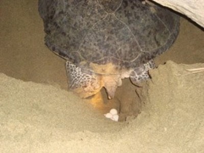
At night, Sukamade turtle beach will be transformed into a paradise. One by one, the turtle will be heading to the mainland from the beach to lay eggs. The moment that is eagerly awaited by tourists, especially foreign tourists. Because it is a rare sight, then treatment must be careful to observe it. Visitors are not allowed to turn on the light and noise while at the beach. The process of laying eggs on the turtle itself takes about 3 hours of riding to the beach to go back to sea again. Some of the existing facilities at the beach Turtle Sukamade: are cottage accommodation, camping ground, meeting hall, trekking jungle track, information center, laboratories, and cottage teamwork.

Sangiran Museum

Sangiran Museum is an archaeological site of Ancient Man in Java, Indonesia. Sangiran lies in the northern city of Solo, about 15 kilometers. Sangiran gate is located on the highway Solo - Purwodadi near the border between Gemolong and Kalioso. Used as a marker to get to the gate of Sangiran, Krikilan village. From the gate to the village of Sangiran site Krikilan is about 5 kilometers.
Sangiran site has an area of ​​about 59, 2 square kilometers, including administratively into two territories: Sragen and Karanganyar regency of Central Java province. In 1977 Sangiran was determined by the Minister of Education and Culture as a cultural heritage. Therefore, the 20th session of the World Heritage Committee in Marida, Mexico on December 5, 1996, determined that one of the Sangiran is World Cultural Heritage No. 593 and this site is listed as a UNESCO World Heritage Site.
In 1934 anthropologist Gustav Heinrich Ralph von Koenigswald begin research in the area of ​​Sangiran. Excavations discovered fossils of human ancestors first was Pithecanthropus Erectus or Java Man. There are about 60 more of these fossils and another fossil Palaeojavanicus Meganthropus found on the site. Sangiran Museum presents the history of early humans between 2 million years ago to 200,000 years ago, which is from the late Pliocene to the middle Pleistocene. Sangiran Museum has a collection of 13,086 ancient human fossils and is the site of ancient humans that stands upright and most comprehensive in Asia. It also found vertebrate fossils, fossil marine plants, water animal fossils, and stone tools. The fossils found in the Sangiran area represent 50% of the fossils in the world and 65% of the findings in Indonesia.

Sultan Palace Yogyakarta

The Sultan Palace Yogyakarta's history began when in 1558 AD, Ki Ageng Pamanahan get a gift from the Sultan area in Mataram for services that has been defeated Aryo Penangsang. Ki Ageng Mangir archery remained always loyal to Sultan Agung to the end, building a palace in Kotagede in 1577. Substitute Ki Ageng Sutawijaya is the son of archery, in contrast to his father. Raden Sutawijaya Pajang refused to submit to the Sultan and want to have their own territory and even dominate the whole island of Java. After winning the battle with the kingdom Pajang in 1588, Mataram became a kingdom and Sutawijaya was the title Sultan Panembahan Senopati. Mataram kingdom has much experienced rapid developments during the reign of the Sultan 4th generation, namely Sultan Agung Hanyokrokusumo. After Sultan Agung died and then was succeeded by his son, named Amangkurat 1.
Mataram kingdom suffered internal conflicts and was utilized by the VOC and ended with Giyanti Agreement in February 1755 which divided the kingdom of Mataram into Surakarta and Yogyakarta Sultanate. In agreement, Mangkubumi be declared Prince Sultan Jogjakarta Sultanate with his Sri Sultan Hamengku Buwana I. In 1988 until now, Jogjakarta Sultanate led by Sultan Hamengkubuwana X. Yogyakarta Palace was founded by Sultan Lane I a few months after the Treaty of Giyanti. The location is a former royal palace of Pesanggarahan named Garjitawati. The houses are used to break the funeral procession of the kings of Mataram to be buried in Imogiri.
Another version states court location is a spring that is named Bannerman Pacethokan and was in the middle of the woods of Beringan. Before occupying Sultan Palace, Lane I inhabit Houses Ambar Ketawang which now includes the District of Gamping, Sleman regency. Location Yogyakarta Palace is between Code River in the east and the river on the west and Winongo Krapyak Stage in the south and Tugu Monument in the north. The site is also located in a line between the Sultan's Palace, the Southern Sea, and Mount Merapi.